Piet's Notes on Deep Creek Lake Science
Sensible Technologies - The Science of Deep Creek Lake
On April 1, 2019, according to MDE Water Appropriations Permit ##GA1992S009 (08), the just referenced document, a new permit must be signed by Brookfield Inc. in order to be able continue operating the Deep Creek Hydroelectric Project.
The conditions listed in the current permit, signed on June 11, 2011, are almost exclusively geared towards specifying when water releases from Deep Creek Lake are allowed for white-water rafting and maintaining the flow in the Youghiogheny river such that stocked trout can survive and be available to the fishing community..
Nowhere in the permit is there any mention regarding the rights of those that own property around Deep Creek Lake and who pay most of the taxes associated with the Deep Creek Lake area.
An argument can be made that the lower and upper rule bands protect the lake property owners, but there have been plenty of cases in the past that insufficient water is retained in the lake to allow recreational boating activities through the summer season.
Much of the work I’ve done and presented on this website is as a result of property owners around Deep Creek Lake having complained in the past about “unboatable” waters during the middle of the summer. In other words, there were times in the past when the water levels in the lake were so low that boats could no longer access their boat slips and as a result boats had to be removed from the lake and put in storage even though the weather conditions were still favorable for swimming, plain old boating, and water skiing. The complaints came mainly from the Southern end of the lake where the waters are shallower to start with and where sedimentation of the shallower coves is more prevalent because of the more agricultural nature of the surrounding landscape.
There is no question that the current permit that MDE issued to Brookfield caters primarily to the white water and Youghiogheny fisheries communities. The words “property owner” is never mentioned in the permit. This was logical when the first permit was issued since it was the prevalent thinking then that these communities would become the economic engines of the County. Time has told us that this did not materialize. The real estate development around the lake became the primary economic resource for the County by far. Property taxes from that sector of the County account for over 60% of its income, while the white water and fisheries industries provide a small, although still to be quantified, income to the County.
It is believed that it is time to modify the permit to reflect the rights of the property owners around the lake first. This needs to be done in anticipation of further growth in this area and to provide with the tools to maintain the lake a healthy habitat for boating and fishing alike. Additional concerns with climate change are thought to be important to lake management rather than white water management.
The above mentioned permit was issued to Brookfield’s predecessor in 1994 (January 1). Over time it has gone from version 01 to version 08.
The Deep Creek Hydro permits start with a small pre-amble and then defines the permit by 25 separate conditions. Except for Condition 19, all conditions underwent small changes from version 01 to 08. Figure 1 describes the various versions.
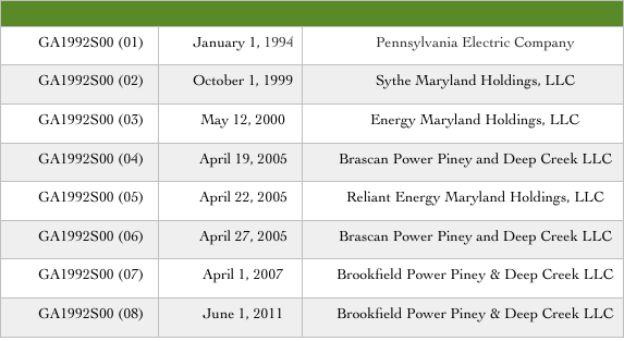
Figure 1. History of MDE-Brookfield Permit # GA1992S00.
One of the basic changes that are important related to the lower rule band. It’s changes are shown in Figure 2.
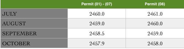
Figure 2. Changing Lower Rule Band with Permit Version.
Condition 19 underwent big changes. Condition 19 evolved over time. In Version 01 condition 19 was about one page long; 07 was about 3-1/2 pages long. Versions 02-V06 were all the same as 01. 07 was the first time an extensive mandatory schedule was specified. 08 has some minor changes, mostly simplifications, but remained essentially the same as 07.
Instead of a general description of when releases were to be made it evolved into a very detailed schedule for very specific releases. There is no real value in repeating it here. Refer to the permits for what they were.
It’s interesting to note that the essence of the permit over time hasn’t really changed. It supports the fishing and white water communities. The permit, over time, has seen more specific language, always in favor of the white water community. The fishing community has seen a degradation, so some extent, because no real effort was made in upgrading the TER methodology. A few coefficients were changed here and there, but its basic shortcomings/inaccuracies were never addressed. There were still non-release days when temperatures exceeded the desirable upper limit of 25 ˚C and there were days when TER releases would probably not have been needed. Would a better TER methodology provide for better results? To me, clearly yes, but they would probably not change the cumulative effect of the releases much.
When considering the permits, from the first version the emphasis was on supporting the fishing and white water communities. When the lake shore was lesser developed over 20 years ago this was probably the most sensible way to go. It was thought that economic development was going to be more successful in the fishing and white-water related industries. They would have been providing the tax base for the County.
The times have changed with a reverse impact of the economic consequences. The tax base of the County now (2017) relies primarily on real estate taxes of mostly second home property owners around the lake. Hence, it is logical to convert the emphasis of the permit on those that make direct use of the lake.
Because river fishing and white water rafting are also mostly performed by out-of-staters, they should also be burdened with maintaining those capabilities.
Another consideration is that reliable sources indicate that there is little fishing activities between the tailrace and the Sang Run river bridge because of difficult access. Then why is TER for that stretch important? It almost appears that stocking the river with fingerlings that grow and in the long term migrate to Pennsylvania.
The following are some interesting numbers. According to this report, SURVEY OF NONCOMMERCIAL RECREATIONAL USE OF WHITEWATER IN THE UPPER YOUGHIOGHENY RIVER, 1996-1997
The survey counted a total of 2,356 boaters from June 7 to October 14, 1996 and 4,249 boaters from April 18 to October 13, 1997. The total number of private boaters projected for the entire boating season (April 15 through October 15) was 3,510 for 1996 and 4,398 for 1997, when adjusted for days not surveyed. In comparison, there were 3,050 and 3,356 commercial raft customers reported for 1996 and 1997, respectively. Seventy-seven percent of boaters used the scheduled whitewater releases in 1996 while over 97% used these releases in 1997, a year in which fewer days were available with ‘boatable’ natural flows or other scheduled and announced releases. Only a small percentage used natural flows, temperature enhancement releases, or other unscheduled releases. Most boaters surveyed reside in Maryland, Ohio, Pennsylvania, or West Virginia. A total of 41 states including the District of Columbia and 11 foreign countries were represented."
Contrast this with [Garrett Chamber of Commerce report, slide 14.](/permit/permit_critique/economics/2009 WVU Survey and Economic Impact.pdf)
- 1,117,744 Visitors per year (estimated 402,388 summer; 310,733 winter; 240,315 fall; 164,308 spring)
Granted that the Upper Yough data are somewhat outdated, there is no recent information available, to my knowledge, and even if so the numbers aren’t expected to be appreciably larger.
I believe that these considerations should be incorporated in a revised permit.
A letter from [Don Cosden (DNR) to Carolyn Matthews and John Wilson, dated January 7, 2011](/permit/permit_critique/trout/PRB - Cosden Letter re. water temp.pdf) suggests a mindset about the importance of the fishery status in the Youghiogheny River that is at odds with science, history and common sense.
The memo quotes a reference to a paper by Carl L. Armour which, in addition to mortality issues for brown trout and its use for sport fishing, also states that brown trout is a non-native and invasive species! Given all of todays concerns about non-native species, this seems odd. It’s great to introduce this, but just for a few people? And at what expense?
Quoting 12-24 inch fish caught by anglers between 1889 and 1929 seems like a very long time ago, when this area was basically a wilderness. The fact that they were still caught 5 years after the lake came to full pool would appear to negate the effect of the dam on the fisheries in the Yough, implying another cause for their demise. I suggest to perhaps look at the impact on water quality by the coal mines.
The Youghiogheny watershed is much larger than the Deep Creek watershed. Suggesting that the latter provided a lot of cold water is at odds with thermodynamic considerations for a smaller creek flowing into the larger Yough.
There are many statements made in the above referenced letter that are just opinions and made without supporting information or evidence:
If the protocol for predicting TER needs was “acceptable,” why “…there were 24 dates when temperatures exceeded 25 °C at Sang Run,…”?
In closing, this letter seems to be addressing the preferences of a very small interest group while totally ignoring, directly, a significantly a much larger community.
It should be reemphasized that I have no basic qualms with the allocation of the water from Deep Creek Lake for the purpose of white-water rafting and fishing, but those communities must also understand today’s realities. The property owners around Deep Creek Lake are the economic drivers for the County and they should be addressed first. With better management practices the same end results can be realized in seasons with plenty of water and a better understanding among the stakeholders can be created during periods of drought.
Probably most contentious issue related to water releases is the TER (Temperature Enhancement Protocol). It certainly was contentious during the development of the Deep Creek Watershed Management Plan.
The following is a description of the Youghiogheny River section of interest to the TER issues:
“From Swallow Falls to Hoyes Run, the Youghiogheny enters a stretch of falls and rapids with a drop in elevation of 280 feet in four miles. At Hoyes Run, a relatively smooth stretch of river can be found all the way to Gap Falls, just north of Sang Run. At that point, the most rugged and inaccessible section of the river runs wild and free to the town limits of Friendsville, dropping in elevation an average of over 100 feet per mile. In 1976 a 21 mile long segment of the Youghiogheny was designated as Maryland’s first Wild River. A state protected corridor along the river runs from Miller’s Run just north of Oakland to the town of Friendsville. This corridor is managed by the Maryland Park Service to preserve the wild and natural scenic, geologic, historic, ecologic, recreational, fish, wildlife, and cultural resources.”
A consequence of the “Wild River Corridor” designation is that, except for near major roads, the river has become essentially non-accessible to fisherman. Furthermore, much of the river flows through private property. Anecdotal evidence from talking to people who travel the river and from plane and helicopter overflights suggest that very few people fish the stretch of the river from the tailrace to the Sang Run river bridge.
Furthermore, from Penelec’s permit Application in 1994, p. 3-62: “During non-release periods, high temperatures can extend throughout the river for short periods during the day. However, numerous tributaries and an estimated 9 cfs leakage from the Deep Creek hydroelectric facility create small, localized pockets of cold water in the mainstem.”